It might come in a bit less that what is being predicted but once you get within a day or two of these snow events they generally get it right. I wouldn't trust the 7-day forecast nearly as much.
I'll post again when I-80 closes.

Here's the forecast for the I-80 summit... breaking 30" of accumulation in a couple different 12-hour periods is big big snowfall. On the high end this is showing 11+ FEET!?
Thursday
A chance of rain and snow showers before 7am, then snow showers. The snow could be heavy at times. Widespread blowing snow, mainly between 10am and 4pm. High near 36. Windy, with a south southwest wind 26 to 30 mph, with gusts as high as 45 mph. Chance of precipitation is 100%. New snow accumulation of 15 to 21 inches possible.
Thursday Night
Snow showers. The snow could be heavy at times. Widespread blowing snow after 7pm. Low around 24. Windy, with a southwest wind 29 to 34 mph, with gusts as high as 50 mph. Chance of precipitation is 100%. New snow accumulation of 25 to 31 inches possible.
Friday
Snow showers. The snow could be heavy at times. Widespread blowing snow. High near 30. Windy, with a south southwest wind 26 to 30 mph, with gusts as high as 44 mph. Chance of precipitation is 100%. New snow accumulation of 23 to 29 inches possible.
Friday Night
Snow showers. The snow could be heavy at times. Widespread blowing snow. Low around 20. Windy. Chance of precipitation is 100%. New snow accumulation of 31 to 37 inches possible.
Saturday
Snow showers. The snow could be heavy at times. Some thunder is also possible. Widespread blowing snow. High near 26. Windy. Chance of precipitation is 100%. New snow accumulation of 18 to 24 inches possible.
Saturday Night
Snow showers. The snow could be heavy at times. Widespread blowing snow, mainly before 10pm. Mostly cloudy, with a low around 15. Breezy.
Sunday
A chance of snow showers, mainly before 4pm. Partly sunny, with a high near 28.
I'll post again when I-80 closes.
Here's the forecast for the I-80 summit... breaking 30" of accumulation in a couple different 12-hour periods is big big snowfall. On the high end this is showing 11+ FEET!?
Thursday
A chance of rain and snow showers before 7am, then snow showers. The snow could be heavy at times. Widespread blowing snow, mainly between 10am and 4pm. High near 36. Windy, with a south southwest wind 26 to 30 mph, with gusts as high as 45 mph. Chance of precipitation is 100%. New snow accumulation of 15 to 21 inches possible.
Thursday Night
Snow showers. The snow could be heavy at times. Widespread blowing snow after 7pm. Low around 24. Windy, with a southwest wind 29 to 34 mph, with gusts as high as 50 mph. Chance of precipitation is 100%. New snow accumulation of 25 to 31 inches possible.
Friday
Snow showers. The snow could be heavy at times. Widespread blowing snow. High near 30. Windy, with a south southwest wind 26 to 30 mph, with gusts as high as 44 mph. Chance of precipitation is 100%. New snow accumulation of 23 to 29 inches possible.
Friday Night
Snow showers. The snow could be heavy at times. Widespread blowing snow. Low around 20. Windy. Chance of precipitation is 100%. New snow accumulation of 31 to 37 inches possible.
Saturday
Snow showers. The snow could be heavy at times. Some thunder is also possible. Widespread blowing snow. High near 26. Windy. Chance of precipitation is 100%. New snow accumulation of 18 to 24 inches possible.
Saturday Night
Snow showers. The snow could be heavy at times. Widespread blowing snow, mainly before 10pm. Mostly cloudy, with a low around 15. Breezy.
Sunday
A chance of snow showers, mainly before 4pm. Partly sunny, with a high near 28.
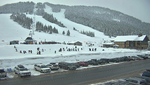
I-80 crosses the Sierra Nevada crest at Donner Summit (also known as Euer Saddle) at an elevation of 7,239 feet (2,206 m) westbound and 7,227 feet (2,203 m) eastbound. The Donner Summit Rest Area is located at this point.[23][24] The summit is located in Nevada County, California. The pass is generally open year-round; it is plowed in winter but may temporarily close during the worst snowstorms.
Last edited: