Understandable, you think trestles is like Honolua bayMy bad. I thought that insta clip was from his visit to the island I referenced for Larry. Mud water in the clip looked like NJ.
Open main menu button
REMINDER: THE ARENA PLATFORM, INC. has no obligation to monitor the Forums. However, THE ARENA PLATFORM, INC. reserves the right to review any materials submitted to or posted on the Forums, and remove, delete, redact or otherwise modify such materials, in its sole discretion and for any reason whatsoever, at any time and from time to time, without notice or further obligation to you. THE ARENA PLATFORM, INC. has no obligation to display or post any materials provided by you. THE ARENA PLATFORM, INC. reserves the right to disclose, at any time and from time to time, any information or materials that we deem necessary or appropriate to satisfy any applicable law, regulation, contract obligation, legal or dispute process or government request. Click on the following hyperlinks to further read the applicable Privacy Policy and Terms of Use.
Un-official 2021 Tropical action thread
- Thread starter potato-nator
- Start date
Anyone have any insight into this?It looks like another hurricane (Odette?) will start to form this weekend and follow a similar path to Larry.
Southern California got some this week. 
Being retired is the bomb. I got two solo or near solo sessions in head high and overhead waves. Today's was also pure glass. I forgot to put sunscreen on and spent three hours staring into the sun but it was worth it.
Being retired is the bomb. I got two solo or near solo sessions in head high and overhead waves. Today's was also pure glass. I forgot to put sunscreen on and spent three hours staring into the sun but it was worth it.
Southern California got some this week.
Being retired is the bomb. I got two solo or near solo sessions in head high and overhead waves. Today's was also pure glass. I forgot to put sunscreen on and spent three hours staring into the sun but it was worth it.
Today was good. Long morning session, followed by after lunch session in trunks. I am a little hypothermic now, though 
earlier info had it stalling off of us....I am seeing a little something off the mid Atlantic late week.
now saying its gonna scoot.


supposedly a major one headed toward USEC; forecast i saw has it side-swiping
PR and Bahamas...
PR and Bahamas...
Yes hurricane Samsupposedly a major one headed toward USEC; forecast i saw has it side-swiping
PR and Bahamas...

Dont even joke like that, I was out of my place for 9 months.Sam sounds a-little-too-much like Sandy...
This scenario makes me nervous. Still way too far out. Some models have this thing jetting off like Larry and then this one on Windy puts it in a place I don't want to see it with a lack of moving parts to steer it away from the mainland. This model happened to be the one that had Larry nailed early on. Hoping this model underestimates the the cold front that pushes off the coast in a few days.
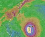
This is not what you want to see if you live anywhere between Savanna and Cape Cod. Windy ECMWF Model for 10/2.
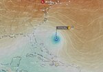
Meanwhile the GFS Model looks like this for 10/2
This is not what you want to see if you live anywhere between Savanna and Cape Cod. Windy ECMWF Model for 10/2.
Meanwhile the GFS Model looks like this for 10/2
It looks like Sam is going to follow a similar path to LarryThis scenario makes me nervous. Still way too far out. Some models have this thing jetting off like Larry and then this one on Windy puts it in a place I don't want to see it with a lack of moving parts to steer it away from the mainland. This model happened to be the one that had Larry nailed early on. Hoping this model underestimates the the cold front that pushes off the coast in a few days.
View attachment 116712
This is not what you want to see if you live anywhere between Savanna and Cape Cod. Windy ECMWF Model for 10/2.
View attachment 116714
Meanwhile the GFS Model looks like this for 10/2
View attachment 116716
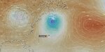
The models are looking a lot more favorable this morning for Sam. Both are in agreement on the track and intensity. They only really differ on the speed that the storm moves northward once it gets past Bermuda.
Interesting to look at the models this morning and see that the North Pacific is starting to light up. Hawaii should be in for a good run of swell over the next couple of weeks.
Interesting to look at the models this morning and see that the North Pacific is starting to light up. Hawaii should be in for a good run of swell over the next couple of weeks.
Just subwayed itIf that GFS model holds, the northeast could easily be twice as big as Larry got. Like once in a generation big (for this part of the world anyway)
Dead glass up here but no forerunnersforerunners here but tide/wind aint with the program...yet...