So how big's it gonna get Wed/Thurs/Fri on west coast?

rowjimmytour

Tom Curren status
Feb 7, 2009
11,534
5,831
113
54
Surfed well OH break that should have been very crowded solo yesterday afternoon. I was only one out until another dude joined me.


had to park creatively and hike in. Will let everyone know when I start pooping blood and puking from the water
North of famous golf course:shrug:
 

estreet

Miki Dora status
Feb 19, 2021
5,133
4,447
113
Southern Cali
this crap was drifting through my local all day yesterday. couldn't get a clear shot of the telephone pole that was further outside, moving from north to south all the way from the rivermouth to channel islands harbor, where the harbor patrol wrestled it for an hour. no thanks. oh yeah, and 1.2 million gallons of raw sewage spilled up in ojai, into the ventura river. yummy!View attachment 145794
Maybe the worst of it has washed out already? :unsure:
 

_____

Phil Edwards status
Sep 17, 2012
6,910
3,176
113
which pier we talking about?
It's the shoreline from the Yacht club in the SB Harbor up a few hundred yards.

Before storm (without sand berm). Those pilings are about 8-10+ feet out of the sand now.
yc.jpg

after storm:

yc2.jpg

Boat yard, looking towards Leds, lots of asphalt already failed.

yc-.jpg

Red is where they've already put rocks or are putting rocks. Yellow looks like it's happening there, too but I'm not 100% certain. (winter sand berm visible ). Google earth pic, all of that sand is gone. At high tide the water is up to those lines and underneath the yacht club.

yc3.jpg
 

ElOgro

Duke status
Dec 3, 2010
32,481
12,595
113
It's the shoreline from the Yacht club in the SB Harbor up a few hundred yards.

Before storm (without sand berm). Those pilings are about 8-10+ feet out of the sand now.
View attachment 145805

after storm:

View attachment 145806

Boat yard, looking towards Leds, lots of asphalt already failed.

View attachment 145808

Red is where they've already put rocks or are putting rocks. Yellow looks like it's happening there, too but I'm not 100% certain. (winter sand berm visible ). Google earth pic, all of that sand is gone. At high tide the water is up to those lines and underneath the yacht club.

View attachment 145807
Just from this storm?
 

r32

Administrator
Staff member
Apr 1, 2005
18,210
10,080
113
Cambria
It's the shoreline from the Yacht club in the SB Harbor up a few hundred yards.

Before storm (without sand berm). Those pilings are about 8-10+ feet out of the sand now.
View attachment 145805

after storm:

View attachment 145806

Boat yard, looking towards Leds, lots of asphalt already failed.

View attachment 145808

Red is where they've already put rocks or are putting rocks. Yellow looks like it's happening there, too but I'm not 100% certain. (winter sand berm visible ). Google earth pic, all of that sand is gone. At high tide the water is up to those lines and underneath the yacht club.

View attachment 145807
Good explain. Thanks for the breakdown. :shaka:

That club looks very low to the ground. One would think they would account for 50 or 100yr storm levels during the design and build process.
 

Surfdog

Duke status
Apr 22, 2001
21,818
2,033
113
South coast OR
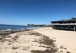
I was gonna say, I remember seeing that pic posted here years back. Compared to recent pics above.
That winter is still the gran-daddy-O of all winters in recent decades, for most all of CA.

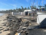
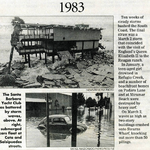
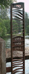
We still have a few months left of winter, and storms are still lining up out to Japan, so we may see as much erosion as El Nino winter 82/83. We're kinda due actually. This is the 40 year anniversary of that winter. Yikes, I'm gettin' old.

Where were you in Jan/Feb 1983? Surf was solid overhead for over 3 weeks straight late Jan/early Feb.
Some days epic. Some days washing machine.

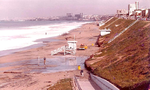
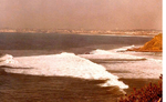
Looking from PV Indicator to Cove. Giant lefts way up from Ski Jump rocks.

PV-Cove-83.png

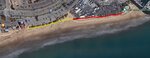
When is the last time you saw the bike path in Redondo covered with sand from waves washing up to cliffs?

Redondo-83.png
 
Last edited:

Mr Doof

Duke status
Jan 23, 2002
25,023
7,980
113
San Francisco, CA
Why was I so darn helpful before...have sent up a dangerous precedent:

View attachment 145539

Follow up report:

1A External outlet with CFCI was had moisture in it and had tripped.
2A Internal powerstrip was cooked as well.
3A Bedroom outlet on same circuit, circuit fired.


1B Dried out the outlet with hairdryer on extension cord, reset CFCI, some some silicon goop to seal cover better.
2B Replaced powerstrip with more robust model.
3C Watched her reset circuit, saw she wasn't doing it properly, so pushed all the way "off" to click, then click back to "on".
4C Turned down bottle of wine as thanks.
 

SteveT

Phil Edwards status
Apr 11, 2005
5,941
2,629
113
Getting some pics of creeks and waterfalls in the Central Sierras and they are swelling fast. This spring going to be an epic melt. Merced River will probably flood Yosemite Valley a bit.
I didn't take the pic.
We were up there over Thanksgiving, I saw this flood water marker on the bridge.
1997 is where the water level was.
When you look around the area it's hard to believe anything was left.

metal-scupture-on-bridge-showing-water-depth-when-Yosmite-Valley-has-flooded.jpg
 

rowjimmytour

Tom Curren status
Feb 7, 2009
11,534
5,831
113
54
Follow up report:

1A External outlet with CFCI was had moisture in it and had tripped.
2A Internal powerstrip was cooked as well.
3A Bedroom outlet on same circuit, circuit fired.


1B Dried out the outlet with hairdryer on extension cord, reset CFCI, some some silicon goop to seal cover better.
2B Replaced powerstrip with more robust model.
3C Watched her reset circuit, saw she wasn't doing it properly, so pushed all the way "off" to click, then click back to "on".
4C Turned down bottle of wine as thanks.
1A a good solid cover that snaps closed when no plugs in and has foam under metal cover plate helps along with silicone around plate and conduit box specially thick on top and sides where h20 runs off walls.