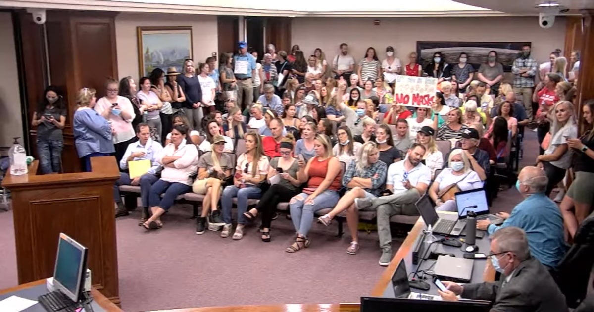
Utah meeting on masks is canceled when residents without masks pack room
"This is the exact opposite of what we need to be doing," a county commissioner said to boos. "We’re supposed to be physically distancing, wearing masks."
REMINDER: THE ARENA PLATFORM, INC. has no obligation to monitor the Forums. However, THE ARENA PLATFORM, INC. reserves the right to review any materials submitted to or posted on the Forums, and remove, delete, redact or otherwise modify such materials, in its sole discretion and for any reason whatsoever, at any time and from time to time, without notice or further obligation to you. THE ARENA PLATFORM, INC. has no obligation to display or post any materials provided by you. THE ARENA PLATFORM, INC. reserves the right to disclose, at any time and from time to time, any information or materials that we deem necessary or appropriate to satisfy any applicable law, regulation, contract obligation, legal or dispute process or government request. Click on the following hyperlinks to further read the applicable Privacy Policy and Terms of Use.

Americans a idiots.
 apple.news


That's a pretty sweet map of population densityAmericans a idiots.

U.S. Coronavirus Cases Hit Another Daily Record as State GOP Officials Target Mask Orders — The Wall Street Journal
Officials in some states prepared for more remote instruction in the coming school year as coronavirus infections continue to rise. Measures aimed at slowing the pandemic are facing political resistance.
A Detailed Map of Who Is Wearing Masks in the U.S. (Published 2020)
The patterns from hundreds of thousands of survey respondents reflect partisanship, peer pressure and the footprint of the coronavirus itself.www.nytimes.com
Out of a population of 330M+141,000 dead.
Like a typical right wing moron. old Chuck sure changed his tune when his kid got covid. I wonder if Trump is going to tweet this?Well, Chuck Woolery is no Whoopi Goldberg, that's for sure.
Going to have to save this one. It's got serious possibilities as an avatar...
The lazy eye'd White Boy and Public Enemy T-shirt really make a statement.Going to have to save this one. It's got serious possibilities as an avatar...
When are you going to die for the economy?Out of a population of 330M+
Meanwhile we've destroyed the economy, countless small businesses, the mental health of millions, and worst of all, are destroying the future of our children
Fixed.That's a pretty sweet map of brain cell density
you’re so predictable.Going to have to save this one. It's got serious possibilities as an avatar...
I'm somewhat skeptical that the citizens of Mono and Eastern Riverside/San Bernadino/Imperial Counties are masked up.Americans a idiots.
It actually isn't; there are shitloads of high density areas that don't show up dark purple, and shitloads of "Cows wear masks?!?!?!" zones lit up.That's a pretty sweet map of population density
Weren't those going down anyway?Out of a population of 330M+
Meanwhile we've destroyed the economy, countless small businesses, the mental health of millions, and worst of all, are destroying the future of our children
New talking point? You really can't go with only the death count matters as death rates are going up in all irresponsible states.Out of a population of 330M+
Meanwhile we've destroyed the economy, countless small businesses, the mental health of millions, and worst of all, are destroying the future of our children
He's going by the fallacy that everyone has already been infected which isn't the case.New talking point? You really can't go with only the death count matters as death rates are going up in all irresponsible states.
I’ve been saying for months that, if we don’t get this under control, we’ll be at 150,000 deaths by mid-July. I was hoping i was wrong and we’d all be laughing at how much we overreacted by now.He's going by the fallacy that everyone has already been infected which isn't the case.
150,000 by end of next week. 300,000+ by election day and that's assuming only 1,000 dead per day. It could end being a lot more. We will learn a lot in the next 2 - 6 weeks.
