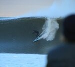
would love to see video footage of that second wave. Looks so heavyWhat would our California and friends in Hawaii call the size of this wave? I've been around a long time and these are the biggest waves I've ever seen attempted in NJ. Paddling that in a 5mm is next level. Water about 45-46.
View attachment 168832
View attachment 168831
Open main menu button
REMINDER: THE ARENA PLATFORM, INC. has no obligation to monitor the Forums. However, THE ARENA PLATFORM, INC. reserves the right to review any materials submitted to or posted on the Forums, and remove, delete, redact or otherwise modify such materials, in its sole discretion and for any reason whatsoever, at any time and from time to time, without notice or further obligation to you. THE ARENA PLATFORM, INC. has no obligation to display or post any materials provided by you. THE ARENA PLATFORM, INC. reserves the right to disclose, at any time and from time to time, any information or materials that we deem necessary or appropriate to satisfy any applicable law, regulation, contract obligation, legal or dispute process or government request. Click on the following hyperlinks to further read the applicable Privacy Policy and Terms of Use.
Entire east coast about to get some action.
- Thread starter Will there be snacks
- Start date
wow, so was every wave in NJ a closeout ?

guess so.
@Subway how was it for you this morning, looked a bit better in your zone than mine.
Just came back from a late check and we're in a closeout positive situation with some fun , but windy, throughout the day.
morning looks like it will be good.
It was really good. I can’t say I made the most of it but I did get one stand out back hand barrel, witnessed by my homie on his way back out. Couple fun rights. Pitched on a big left. Cold. Mid 30s with a brisk north wind. Not uncomfortable but I was pretty fatigued after 90 minutes or so.
overall a great morning but I’m also ready to retire to Nicaragua
overall a great morning but I’m also ready to retire to Nicaragua
Might be epic shirts Jason smith
Let me guess, he’s from the Niagra Falls area and we wouldnt know him?I did get one stand out back hand barrel, witnessed by my homie on his way back out
It’s not the existence of said bro I find dubious lolI have friends I swear.
Last edited:
Insane! Much respect to those charging it. Love when jersey gets dirty.
18' @ 12 seconds! That has got to be a record for around here in December...
I am going to go with this or I think maybe Mundus posted a more Jersey-centric reading. Ridiculously tall, and extremely mixed up. The buoys don't really tell the whole tale of this storm or storms like it. You get multiple extremely punchy short period swells and a buoy sampling for one or two swell readings is only telling part of the story.For the waves on the videos just above, what were the buoy readings?
A single-direction strong howler, like a stationary March gale, approaching this kind of reading is probably not going to produce this kind of face height or swell speed. You need mixed direction in geographic and chronological proximity to make constructive interference.
A good Cape Verde hurricane that recurves just out past the Bahamas will send a place like North Florida a 2-3@18 then 3-5@15 then 2-4@12 with the direction clocking from ESE to ENE/NE over the course of its swell lifecycle. The start of this swell will be HH to a bit OH+. We just don't have the bathymetry to allow that swell to really jack up. The lines will tend to be long and reminiscent of point surf.
This will generally be approachable on almost anything. The longboarders will get their asses kicked when sets come, but turnturtlers with any gumption (and some ditchers) will get out. Grovelly alts go fine in this kind of stuff. Maybe skitter on the first bottom/top turn if you take off in the hook on a set, but the drops will be mellower than lots of shorter period chunks and the duck diving far less frequent - there might be a bit more drag, but you won't get nearly as rumbled. The swell speed will be just okay and if it's under head high the lip can feel very soft where you want to turn just under it to not get left out the back. Your paddling in concerns will be flatter faces and longer walls you want to start pumping across earlier, not swell speed.
A good frontal "suck up" swell will be like 4-7@6-8. It'll be predominantly SE/SSE, then the wind will clock SW-W and blow it flat. It'll be HH chunks often going square - flat rocker boards will require management they didn't necessarily require on the long period - and if you get one of these on the head you will be doing underwater gymnastics vs getting more dragged by the less critical long period. And there's a shitload more of them - boards that can't duck dive need not apply. This surf will be lippier than the long period and more ledge on takeoff, but you won't need much paddle to match the swell speed and there will usually be a great chip in unless the sandbar is ultra ledgey. Spin, two stroke it, pop up. This is the surf a Floridian will be trying no-paddle takeoffs or takeoff rolls if sponging.
Then you get strong mixed direction events like this one. Cutoff lows, early season slow-moving tropical stuff, extra-tropical storms. The scenario is generally relatively stationary low in the Gulf or off Carolinas/Georgia/Florida gets some warm water going, then a front mixes in and it explodes. Or if Florida is very very lucky, a big Low will drop down out of Ontario/Quebec, hit 70 degree Gulf Stream water, and explode. Or a late season hurricane like Sandy will merge with a storm kind of like this and have hurricane-style winds with temperate latitude fetch.
These high velocity mixed direction storms are producing 18@12 but it's really like different direction 12@12 with offshores and when those coagulate on our normally more docile sandbars, the constructive interference gives it the illusion/characteristics of a groundswell somewhere good (canyon or greater than 180 degree exposure refraction) - the wave is larger, hauling ass towards shore, AND it'll jack and throw.
^ - Thanks.
Big with short period makes sense to me for those waves.
Why?
East Coast has a fair bit of continental shelf.
Short period swell (from storms close by) does not reach down very far (while long period swell does).
As such, shorter period waves wouldn't lose that much energy (from a storm close by).
It would be interesting to see what would have happened to that swell with 500+ miles to organize.
The Thanksgiving waves we had in SF were around 8-9 ft at 21+ seconds, and some of the sets look (from the video) to have been about the same size.
One point a guy with CDIP (developed the buoy models originally) made to me re East Coast is that when it gets to a certain size and the waves are scraping the seafloor way out (along the Cont Shelf), the seafloor becomes a muddy slurry and so the swells don't get knocked down nearly as much as they would if the swell was just grazing the seafloor. It's almost like they're sliding across a slippery floor instead of dragging. Lots of dynamics at work.
21+ is gnarly wave speed and power.^ - Thanks.
Big with short period makes sense to me for those waves.
Why?
East Coast has a fair bit of continental shelf.
Short period swell (from storms close by) does not reach down very far (while long period swell does).
As such, shorter period waves wouldn't lose that much energy (from a storm close by).
It would be interesting to see what would have happened to that swell with 500+ miles to organize.
The Thanksgiving waves we had in SF were around 8-9 ft at 21+ seconds, and some of the sets look (from the video) to have been about the same size.