Open main menu button
REMINDER: THE ARENA PLATFORM, INC. has no obligation to monitor the Forums. However, THE ARENA PLATFORM, INC. reserves the right to review any materials submitted to or posted on the Forums, and remove, delete, redact or otherwise modify such materials, in its sole discretion and for any reason whatsoever, at any time and from time to time, without notice or further obligation to you. THE ARENA PLATFORM, INC. has no obligation to display or post any materials provided by you. THE ARENA PLATFORM, INC. reserves the right to disclose, at any time and from time to time, any information or materials that we deem necessary or appropriate to satisfy any applicable law, regulation, contract obligation, legal or dispute process or government request. Click on the following hyperlinks to further read the applicable Privacy Policy and Terms of Use.
***Official 2020 Tropical Weather Thread***
- Thread starter ElOgro
- Start date
Talk about festeringgulf festering.
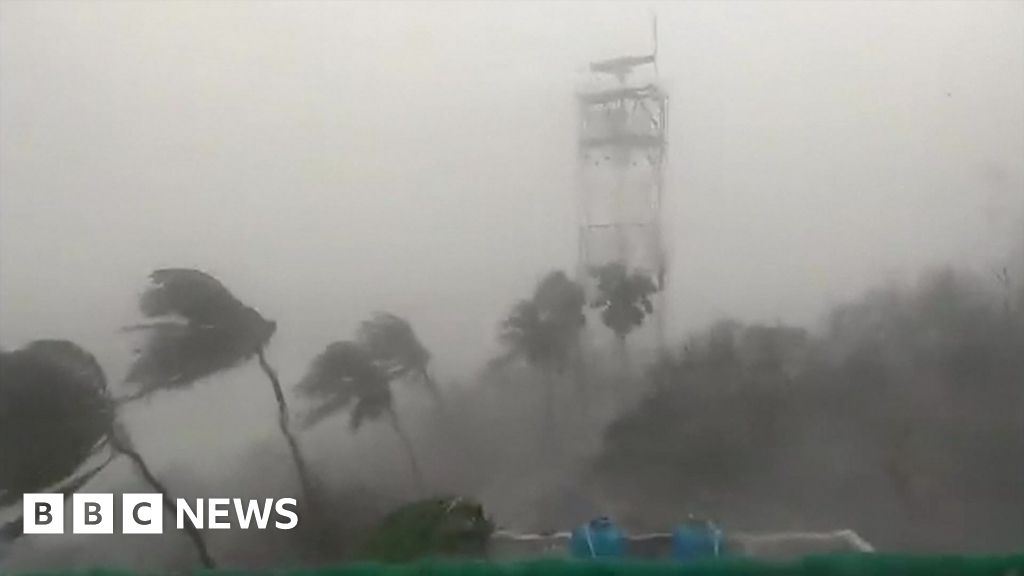
Cyclone Nisarga: India's Mumbai escapes worst cyclone in decades
India's financial capital narrowly escapes Cyclone Nisarga, as nearby areas bear the brunt.
www.bbc.com
Mumbai under water.

Strongly considering heading tomorrow morning. Went to Tallahassee once, other than that, never been up/out past Gainesville or Cedar Key.
Been doing the Google Maps/Surfline/NHC thing.
Worried it'll be so nuclear crowded I wish I'd just stayed put and got some windslop here Sunday.
Been doing the Google Maps/Surfline/NHC thing.
Worried it'll be so nuclear crowded I wish I'd just stayed put and got some windslop here Sunday.
And the locust.and a combo punch - they have the bug too.
Strongly considering heading tomorrow morning. Went to Tallahassee once, other than that, never been up/out past Gainesville or Cedar Key.
Been doing the Google Maps/Surfline/NHC thing.
Worried it'll be so nuclear crowded I wish I'd just stayed put and got some windslop here Sunday.
Ha, top upvote is the Florida Gators official youtube channel saying we'll miss you Tom.
After he died, between 3rd and 4th quarter every home game, the fans sing "Won't Back Down" after singing "We are the Boys".
You guys who'd know, some of that older footage ( :15-1:04) 70s or 80s?
Last edited:
I think you should fire over. It looks like it’s gonna pump late in the day.Strongly considering heading tomorrow morning. Went to Tallahassee once, other than that, never been up/out past Gainesville or Cedar Key.
Been doing the Google Maps/Surfline/NHC thing.
Worried it'll be so nuclear crowded I wish I'd just stayed put and got some windslop here Sunday.
What’s the drive again? I guess not that far from jax? From the storm forecast it looks like 500+ miles straight up from the bottom of the gulf to the top with 40/50 mph wind.I think you should fire over. It looks like it’s gonna pump late in the day.
Looks like 4-4.5 to Panama City Beach area which seems like the best idea with ESE winds.What’s the drive again? I guess not that far from jax? From the storm forecast it looks like 500+ miles straight up from the bottom of the gulf to the top with 40/50 mph wind.
There's already a little bump there now. Strangely the cams farther West look dead damn flat at the moment, but I'd be out surfing up the front if it looked like it does in PCB right now.
He’s one of those hope springs eternal guys.have a bad day?
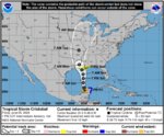
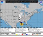
The latest from NOAA
Remnants of Bret Public Advisory
www.nhc.noaa.gov
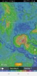
Cristobal is forecasted to rain on up through a path up the middle
We’ve had drizzle since before dark, two weak lightning fizzles over the ocean, and one thunder from the mountains out back. Word from my brother in law is that it’s raining steady an hour south of us.
Any surf reports from the panhandle? Possible Diro sighting?
Got headed out in the pre-dawn gloom Saturday. Rainy drive out; very light traffic. Made it to everyone's favorite peaky inlet/jetty spot. Chest-headish and fun. It was packed but watching, I saw some missed, etc. Seemed like tons of people sitting juuuust a hair too far out. Wound up kind of catching quite a few waves even though it was crowded. Lots of peaks on offer and everyone waiting the hero set and lots of people not able to get under the double ups.Any surf reports from the panhandle? Possible Diro sighting?
Surfed for a few hours after that drive, felt a little tired, decided to do some fishing. Pissing down rain and brisk wind at this point. Drove to back side of barrier island, walked just down the way, found a grassflat with good current and bait. Several trout, 2 in the 20" range, and a redfish. Broke my travel rod casting my lure into the wind. Then decided to do some scouting. Found some uninspiring looking brown water closeouts in one spot, say waist, and some slightly more inspiring but generally uninspiring lefts up the beach at another spot. Say stomach? Wind was great in the 2nd spot, just a little too closed out. It had potential though.
Sunday morning I felt like I could barely move after that drive, surf, and then the afternoon drive scouting. Went back to Plan A, and it was on the edge of overwhelmed at high tide but some good tubes on offer even though I didn't get any to set up. It got fully overwhelmed, lots of washthroughs, less rhyme and reason. Lot of current too - drifts happened fast. A very nearby place I was too tired to try paddling to (and back from) looked like it was starting to work. Funny seeing how many surfers there have jet skis. sh!t. Loads.
Drove back to the other spots as the wind was clocking and they're in the general direction of home even if not actually shortening the time due to distance from Interstate.
The waist high closeout place was overhead, but very side/devil wind-whipped. Looked kind of maybe-able, but not sure. Lots of people checking it. Decided to try to get some lefts. Drove all the way around, hit a roadblock. The surf was hitting the coast road, which is armored, and the smaller rocks were washed into the road. Waited about 5-10 and the dozer cleared the larger rocks. Splash from surf going over the car, surge coming through the shoreline boulders when the waves hit.
Got to a parking spot, checked it. Whipping current, wind a bit too side off but really just too stormy. Well over head out the back but again, I'd be half a mile at least before I got out the back, and forget lining anything up.
Decided to bag it and head home.
Here is where the fun actually starts.
It had been oddly sunny yesterday out in the Panhandle, with the heavy rain out towards the middle of the state. Very pleasant drive up the back roads out there to I-10, actual turns and some minor elevation changes. Wee.
Get on I-10, weather starts to turn South. Fumbling with Nav and Weather on cell phone, see what appears to be a wreck/slowdown on I-10, and I see some bypass roads. The mapping app didn't show it, but I-10 was completely closed due to flooding. I get to exit before where I see the traffic starting to back up, and there's a road around the dark red on the mapping app, that's like a mile. Okay.
I get off I-10, po-ass-dunk nowhere. Find the left, and it's a dirt road. I start going down this beautiful country dirt round, incredible old oaks on parts of the properties that aren't pasture-cleared, muddy, traction control going haywire at 20mph. Come across some flooded spots and decided to go for it. Make it across, a couple more flooded spots, finally, get back to pavement on the road with an I-10 on-ramp. Get up I-10, and I see everyone exiting I-10 Eastbound, I-10 Westbound almost completely empty. Hmm. Get waved through an impromptu 4-way stop with highway patrol directing traffic, and it's stop and go in the middle of nowhere, and the detour looks to be like 20 miles.
Why are they doing this?
Suwannee County backroads are mental in heavy rain, that's why.
I look at the map and see the back roads they're sending us down are jammed, and it's stop and go the instant I'm off I-10. I turn off and am able to park on the side of the road, about to collapse the sod into flooded pasture. Pull up my phone, and see back roads I can take generally to the I-10/I-75 interchange, but South of I-10 away from the massive traffic jam forming to bypass the closure, and just say f--k it.
Pretty soon it's pouring rain, visibility is atrocious, and the flooding....on these back rounds...the speed limit is 55. Some guy is passing, gets around me, tries to pass some car in front of me, hits a flooded part at like 70, sends a blast of water like 40 feet into the air, fishtails, gets back on the gas...I am following locals going 60 and we're spending most of the time in the oncoming lane, or smack-middle depending on the flood, and I don't want to lose them because they know where it's flooded and I'm avoiding it by following them. Even still, I hit the floodwaters, and the car lurches and then hydroplanes. A couple places, the road-wear ruts are deep leading to a turn, and the car basically starts sliding/planing into a turn. Yikes. This went on for like 30 minutes of white knuckle, traction control, letting the car plane, slide, and regain grip, probably saved 10 accidents at least. I gain some more elevation and the flooding seems a little more localized, but the roadside rentention is flooding in spots and turning into an arroyo as it over tops. Californians are used to this in the high desert but with sh!t visibility in pouring rain, lots of turns and blind spots due to undulations, it's hectic.
Finally get out of all that, the rain starts to lessen, as I'm headed into Live Oak (BFE middle of nowhere North Florida). There are several roads headed to I-10 from here; swell. I pick the largest one, and it's closed. I see another one headed East that looks like it intersects. There's a cop in the road, high water sign, and I can't see how deep it is. Non-lifted passenger car. Nope.
Headed back along another road E/ESE just to keep going in the general direction. More of the same. Streams hitting the retention ditch on the road, that tops, flows down across the road to the next one in a fast sheet of water. See a turn that takes me back towards I-10. Get on it, does not seem like an I-10 road. Then I see a semi hauling major ass, and I realize it doesn't have a ramp. Check phone again, find one with a ramp a few miles East. Another few turns, some more stream fordings and saved accidents later, and then I'm back on I-10.
The semis' tire ruts are full and the right lane is a hydroplane fest. I have a few more car planes, gets turned, regains grip, slight jolt, but at least I know where I'm going. Another hour, home dead tired. Slept like a log from 10:30 to 8am.
I'll probably go back for surf, I'll probably try to day-trip river fishing some of those wild blackwater rivers, and I'd heard about I-10 having flooding problems, and in some ways there are more rural roads as back routes than I-95, but man that is the middle of nowhere, the roads are in terrible shape, and horrible in heavy rain.
Surfed a new spot, got some tubes, some lip tags, some fish, saw a bunch of new sh!t I hadn't seen, almost died like 30 times.
1.5 years or so later after Michael in 2018, and I can tell you, that zone from Panama City Beach through Port St. Joe/San Blas got COMPLETELY FCKNG CLAPPED. Upside the head. All kinds of just obvious destruction.
also fending off Chinese military in HiMAlayas.have a bad day?
These days, cooler weather in the lower latitudes usually means warmer weather in the Arctic. I have a feeling of foreboding.It’s that time of year again. It’s been a strange spring for us, normally any time after mid April it’s HAF, this is the first time in the last 25 years that I can remember sleeping without a fan in the end of May.

Climate crisis: alarm at record-breaking heatwave in Siberia
Unusually high temperatures in region linked to wildfires, oil spill and moth swarms
 www.theguardian.com