Open main menu button
REMINDER: THE ARENA PLATFORM, INC. has no obligation to monitor the Forums. However, THE ARENA PLATFORM, INC. reserves the right to review any materials submitted to or posted on the Forums, and remove, delete, redact or otherwise modify such materials, in its sole discretion and for any reason whatsoever, at any time and from time to time, without notice or further obligation to you. THE ARENA PLATFORM, INC. has no obligation to display or post any materials provided by you. THE ARENA PLATFORM, INC. reserves the right to disclose, at any time and from time to time, any information or materials that we deem necessary or appropriate to satisfy any applicable law, regulation, contract obligation, legal or dispute process or government request. Click on the following hyperlinks to further read the applicable Privacy Policy and Terms of Use.
2022 Tropical Systems
- Thread starter potato-nator
- Start date
Personally the paths are golden. The problem is the good one is way TF out in the ocean, and the one with the nice path is about a fart in the wind in terms of energy.the path of the latest noAtlantic systems.....suggests (LATE SEASON?)...
60 days ago it was early July. Entering the Depths of Hell.
60 days from now it will be November. Salvation.

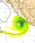
A potential historic storm is currently organizing off Mainland Mex. The latest European model run has a massive Cat 5 storm, Hurricane Kay, passing just to the SW of Cabo early next week. If it stays on that track or better yet shifts further West, for Cabos sake, this storm will produce a historic East Cape swell event. Hey overhyped Atlantic basin, hold my cerveza!
Subject to change
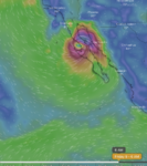
Subject to change of course:A potential historic storm is currently organizing off Mainland Mex. The latest European model run has a massive Cat 5 storm, Hurricane Kay, passing just to the SW of Cabo early next week. If it stays on that track or better yet shifts further West, for Cabos sake, this storm will produce a historic East Cape swell event. Hey overhyped Atlantic basin, hold my cerveza!
View attachment 137181
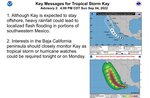
Not sure where the talk of Kay reaching Cat 5 is from? But as it stands today, max is just into Cat 2 SW of Cabo on Wed afternoon. Then back down to Cat 1 just west of Mag Bay by Thur. afternoon.
Has NOAA downgraded their models that much already?
Even their cone chart doesn't show an M for major, which even a Cat 3 qualifies.

Water temps are still fairly cool (mid-upper 70's) just west of Baja Sur Pacific side, barely tropical storm capable.
Has NOAA downgraded their models that much already?
Even their cone chart doesn't show an M for major, which even a Cat 3 qualifies.
Water temps are still fairly cool (mid-upper 70's) just west of Baja Sur Pacific side, barely tropical storm capable.
Last edited:
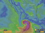
Yesterday, I did notice what looked like a major hurricane there (west of Mag Bay) later this week on the Tropical Tidbits site collection of charts.
Then checked Surfline forcasts for the area, and they had Mag Bay area forcast 40-50ft by Wed/Thurs.
Those both peaked my interest in a storm that hadn't even developed yet.
We'll see, but NOAA looks to have backed way off those forcasts.
Edit: Just now checked Surfline forcast for Mag Bay to Abre's. Now 30-40ft by Wed/Thurs.
Of course it'll be stormsurf mayhem with center of storm hopefully staying off the coast, no matter what category it reaches.
Last edited:
What do you recommend, high tide or low tide? Asking for @ricesan felipe pits!
La Baja es gonna get shanackered.

One good thing for So Cal interests now, is that Kay is moving more west than previous forcasts, before she heads north.
She's still not quite in the So Cal window, but should edge into it tomorrow and Wed, while heading more north (if it follows todays forcast movement). Good for all, if she stays further out off Baja Sur as she heads north. Next 2 days is key.
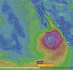
They've boosted max intensity a bit more, and she looks solid on sat views. Now might make it to just under Cat 3 max, but she could intensify more in the next 24-48 hrs before hitting cooler sea temps just WSW of Cabo by late Wed.
If she can get out just enough past Punta Eugenia, So Cal can get a solid very SSE swell. If she's stay tucked closer to Baja Sur, So Cal sees little to none, unless she passes over the point and can give some more local SSE swell off North Baja, which is kind of rare, but still can happen if she stays strong.
So Cal might get some blow off weather/rain by next weekend if it makes that far north somewhat intact.
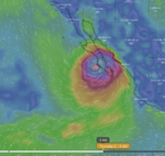
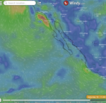
(above) Forcast for Friday late afternoon. Still solid isobars just north of Punta Eugenia, with right side of Kay still just barely over ocean. Localized, solid very SSE swell for So Cal could result?
IF, big IF, she can keep her strength that far north.
Surf sacrifices should be on order and rushed to completion.
She's still not quite in the So Cal window, but should edge into it tomorrow and Wed, while heading more north (if it follows todays forcast movement). Good for all, if she stays further out off Baja Sur as she heads north. Next 2 days is key.
They've boosted max intensity a bit more, and she looks solid on sat views. Now might make it to just under Cat 3 max, but she could intensify more in the next 24-48 hrs before hitting cooler sea temps just WSW of Cabo by late Wed.
If she can get out just enough past Punta Eugenia, So Cal can get a solid very SSE swell. If she's stay tucked closer to Baja Sur, So Cal sees little to none, unless she passes over the point and can give some more local SSE swell off North Baja, which is kind of rare, but still can happen if she stays strong.
So Cal might get some blow off weather/rain by next weekend if it makes that far north somewhat intact.
(above) Forcast for Friday late afternoon. Still solid isobars just north of Punta Eugenia, with right side of Kay still just barely over ocean. Localized, solid very SSE swell for So Cal could result?
IF, big IF, she can keep her strength that far north.
Surf sacrifices should be on order and rushed to completion.
Last edited:
san felipe tides? depends, what minute are you asking about
