REMINDER: THE ARENA PLATFORM, INC. has no obligation to monitor the Forums. However, THE ARENA PLATFORM, INC. reserves the right to review any materials submitted to or posted on the Forums, and remove, delete, redact or otherwise modify such materials, in its sole discretion and for any reason whatsoever, at any time and from time to time, without notice or further obligation to you. THE ARENA PLATFORM, INC. has no obligation to display or post any materials provided by you. THE ARENA PLATFORM, INC. reserves the right to disclose, at any time and from time to time, any information or materials that we deem necessary or appropriate to satisfy any applicable law, regulation, contract obligation, legal or dispute process or government request. Click on the following hyperlinks to further read the applicable Privacy Policy and Terms of Use.
*** Official Backpacking Thread ***
- Thread starter afoaf
- Start date
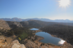
Small National Park. Very few trails. Limited parking. One entrance on East, one entrance on West. Both dead end in the park and do not connect. Two awesome cave areas. Popular with rock climbers. Hot as hell during summer and fall. Rim trail has amazing views. Have lunch at the reservoir with the other 200 people you passed in the caves.
haha well, not the review I was hoping for.Small National Park. Very few trails. Limited parking. One entrance on East, one entrance on West. Both dead end in the park and do not connect. Two awesome cave areas. Popular with rock climbers. Hot as hell during summer and fall. Rim trail has amazing views. Have lunch at the reservoir with the other 200 people you passed in the caves.
Just got off the phone w Hearst. Said all SLO parks closed until the county rescinds the locals only camping rule.
Hopefully that will end soon and we can save our SSSP trip at end of September.
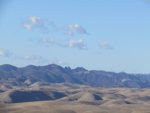
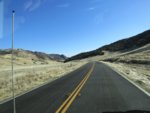
Also, Highway 25 was deserted and so beautiful.
Frozen dishwater-
From a distance-
bro. I've done all the work for you. let's talkI spent the whole morning going through this thread because it is really something I want to do...but it's starting to sound like sailing. $$$$$$. And like sailiing, the lighter, more efficient you go, the more $$$$$$$$$$$.
What would you estimate is the total cost of your whole kit?
And then I would have to times that by 3 to include the family.
also, I hate my pack. I was going to return it to REI for the warranty.
if you want it, you can have it...check sizing though...it's a medium
Gregory Deva 70L (I bought the women's in a pinch, but the REI guy said
the specs are the same regardless of gender, I am moving to a more
simplified and lighter option.)
I still have to process pics, but I made over 50 miles through GTW, SEKI,
and JMW. I woke up with ash on tent every morning, but with clear skies
through the day with the exception of yesterday...it was full on apocalypto
coming over Army Pass...the Owen's Valley was a mess...you couldn't see
the Whites from the Sierra the smoke was so thick. gnarly accident and traffic
jam north of Olancha.
Our permits to go back in to Miter Basin on the 17th are in question now...
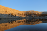
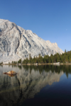
I have only been there once and that was during the height of the pandemic and it was only open to campers and walk/bike-ins. Empty! I hiked the High Peaks trail loop, cutting through the Tunnel trail, and didn't see a single person until I got to the reservoir. In fact, I saw more California condors than people over a several mile stretch. Come to think of it, I didn't see anyone at the reservoir either.
Camped on the east side, just main campground area on smaller loop. Campsite 10 was great as it was separate from other campsites, somewhat near the water spigot, and had a big grassy field with paved loop for kids to play. If you have kids, it's a great campground for them to ride bikes, scooters, etc. Not too many sites in that area either so there isn't a lot of foot or car traffic. Also a camp store which has plenty of supplies and ice cream for the kids.
I thought the park was great and would love to go back. However, I could very well see it being a shitshow once fully open to the public. Like anywhere else, start your hikes early, avoid the more popular ones to avoid people. Active wildlife. Middle of night right behind tent heard a rabbit get taken down by a bobcat (or similar). Loud screeching that was suddenly cut off and then the sound of a body being dragged through leaves and mud. Good times. However, didn't see anything threatening during the day. Mostly just deer.
Summer is hot there and the hikes are generally pretty exposed. I think December would be pretty nice temperature-wise and I would think you'd have a lot less people than summer.
It may have been because of pandemic but firewood was pricey ($10/bundle) and they didn't give you a lot (5-6 small/medium logs).
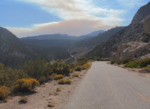
I assured her that I was staying high in the GTW, leaving the fire 30 miles below the southermost
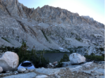
legs of my route...it didn't really look that far away pulling in to the trailhead:
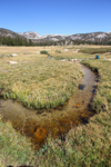
I slept at the trailhead on Thursday night and pushed out at first light on Friday morning so I could get
over Cottonwood Pass before the sun really got on it...I got up and over in to Big Whitney Meadow in
about 3 hours. This is facing north towards Siberian Pass
The trail to Rocky Basin Lakes is faint at best, but there were ducks and the final climb stayed along
a cool little drainage with plenty of shade.
(I cannot stress enough how much Leukotape, sock liners, and a little petroleum jelly help to prevent
blisters....I pretaped based on where I got blisters on my last trip with breaks to dip them in a stream
and air dry)
I stayed at the westernmost lake in the chain, made dinner, hung my food, and collapsed at about 7pm
 \
\The smoke started pushing in that evening when the winds turned, but by morning the sky was clear
and still
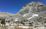
The second day was all off-trail for the first half, going cross country up and over the Boreal Plateau,
past Funston Lake, and down a saddle in to the west end of Siberian Outpost towards the Rock Creek
section of the PCT
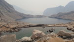
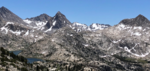
The smoke pushed in heavily during the afternoon, making Guyot Pass a fkn hell-slog...I got to the lower
Crabtree Lake out of the Meadow at 6pm after ten and a half hours and sixteen miles. When I woke up
the Crabtree Basin was perfectly clear and empty, making for a superb sunrise.
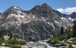
Today would be the big one with the ascent up the basin and over Crabtree Pass in to Miter Basin
(the smoke arrived a bit early today)
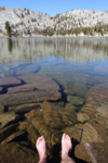
I ate, cooled off in the lake, and drank a ton of water in preparation for the climb. Once I got going up
the pass, the original line I chose was abandoned in favor of a more direct route up, following some
existing ducks and footprints up the east side of the saddle.
The pass is over 13,000 and I was feeling it at the top...nauseous, headache, unquenchable thirst.
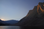
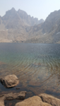
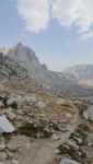
The Miter Basin is otherworldly....the descent was brutal with lots of rock scrambling and no obvious
trail down, but the pain is mollified a bit by the amazing chain of lakes and the incredible faces on the
valley walls...more fkn smoke ruining my pictures.
The Miter on the upper left...this is taken from the shore of Sky Blue Lake
I pushed all the way down, took a dip at Soldier Lake, and pushed up to the junction of the PCT and
the trails to Army and Siberian Passes.
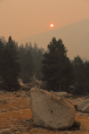
In the middle of the night you could smell the smoke pushing in heavily....as opposed to previous
mornings, I woke up to this madness on Monday - this is not modified or saturated - the sun rising
over Army Pass.
The smoke really put a damper on the hike out...I was hungry and the air quality was miserable so
I didn't tarry much. I just pushed out directly to the trailhead so I could drive out. It was nice to
pass a group on the way up to Langley who confirmed that while there were new fires nearby, our
area was still generally clear and safe. I was worried that with the smoke as bad as it was that
there may have been fires in our immediate area.
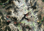
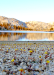
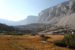
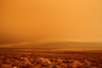
The entire Owens River Valley was a martian hellscape...this photo is also not saturated or otherwise
modified...this is taken from the 395 across the valley to the east....the smoke is so thick you can barely
make out The White Mountains...
I never had a girl like it when I sent her a dick pic.I'd get one mostly so my dad will STFU about it

Woman Receives Dick Pic Via Garmin Mini
Woody Gap, GA- Michaela Green was on a three week section hike of the Appalachian Trail when her life on trail was forever changed. "I was really missing my boyfriend Jeffery who was back home in Middle Wicket, New York. I had not seen him for two weeks and was getting rather lonely," Green told...www.ultralightjerk.com
I got a big one too.

That last orange picture is spooky!
Nice photography. You got an eye for it!The ranger called me to talk about my permit to make sure I knew about the Sequoia Complex Fire....
I assured her that I was staying high in the GTW, leaving the fire 30 miles below the southermost
legs of my route...it didn't really look that far away pulling in to the trailhead:
View attachment 97492
I slept at the trailhead on Thursday night and pushed out at first light on Friday morning so I could get
over Cottonwood Pass before the sun really got on it...I got up and over in to Big Whitney Meadow in
about 3 hours. This is facing north towards Siberian Pass
View attachment 97493
The trail to Rocky Basin Lakes is faint at best, but there were ducks and the final climb stayed along
a cool little drainage with plenty of shade.
View attachment 97495
(I cannot stress enough how much Leukotape, sock liners, and a little petroleum jelly help to prevent
blisters....I pretaped based on where I got blisters on my last trip with breaks to dip them in a stream
and air dry)
I stayed at the westernmost lake in the chain, made dinner, hung my food, and collapsed at about 7pm
View attachment 97496\
The smoke started pushing in that evening when the winds turned, but by morning the sky was clear
and still
View attachment 97497
The second day was all off-trail for the first half, going cross country up and over the Boreal Plateau,
past Funston Lake, and down a saddle in to the west end of Siberian Outpost towards the Rock Creek
section of the PCT
View attachment 97498
The smoke pushed in heavily during the afternoon, making Guyot Pass a fkn hell-slog...I got to the lower
Crabtree Lake out of the Meadow at 6pm after ten and a half hours and sixteen miles. When I woke up
the Crabtree Basin was perfectly clear and empty, making for a superb sunrise.
View attachment 97499
View attachment 97500
View attachment 97501
Today would be the big one with the ascent up the basin and over Crabtree Pass in to Miter Basin
View attachment 97502
Thanks for letting us participate vicariously in your Mars mission. Scary.The trail fades above the previous pic, leaving plenty of time to pick your lines as you approach the pass itself...
(the smoke arrived a bit early today)
View attachment 97503
I ate, cooled off in the lake, and drank a ton of water in preparation for the climb. Once I got going up
the pass, the original line I chose was abandoned in favor of a more direct route up, following some
existing ducks and footprints up the east side of the saddle.
The pass is over 13,000 and I was feeling it at the top...nauseous, headache, unquenchable thirst.
The Miter Basin is otherworldly....the descent was brutal with lots of rock scrambling and no obvious
trail down, but the pain is mollified a bit by the amazing chain of lakes and the incredible faces on the
valley walls...more fkn smoke ruining my pictures.
View attachment 97504
The Miter on the upper left...this is taken from the shore of Sky Blue Lake
View attachment 97505
I pushed all the way down, took a dip at Soldier Lake, and pushed up to the junction of the PCT and
the trails to Army and Siberian Passes.
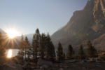
In the middle of the night you could smell the smoke pushing in heavily....as opposed to previous
mornings, I woke up to this madness on Monday - this is not modified or saturated - the sun rising
over Army Pass.
View attachment 97506
The smoke really put a damper on the hike out...I was hungry and the air quality was miserable so
I didn't tarry much. I just pushed out directly to the trailhead so I could drive out. It was nice to
pass a group on the way up to Langley who confirmed that while there were new fires nearby, our
area was still generally clear and safe. I was worried that with the smoke as bad as it was that
there may have been fires in our immediate area.
The entire Owens River Valley was a martian hellscape...this photo is also not saturated or otherwise
modified...this is taken from the 395 across the valley to the east....the smoke is so thick you can barely
make out The White Mountains...
View attachment 97507
did you see comment above re: pack and gear?Thanks for letting us participate vicariously in your Mars mission. Scary.
I have a pack that I'm considering returning to REI under warranty for some reasons
that wouldn't necessarily make it a deal breaker for you if you think you and your family
would get some use out of it....I might backtrack and request a bit of a barter as I need
help with a probox retrofit ; )
beyond that, if you ever want to give it a shot, you can use my gear so you can see what
it's all about before making any financial commitments.
you can get a decent kit for a pretty reasonable price if you know what/where to look.
I have done a bunch of legwork there and can help out as you start researching, but
like I said, you're more than welcome to use my stuff.
Where you said you HATED it...and then wanted to give it to me?did you see comment above re: pack and gear?
I have a pack that I'm considering returning to REI under warranty for some reasons
that wouldn't necessarily make it a deal breaker for you if you think you and your family
would get some use out of it....I might backtrack and request a bit of a barter as I need
help with a probox retrofit ; )
beyond that, if you ever want to give it a shot, you can use my gear so you can see what
it's all about before making any financial commitments.
you can get a decent kit for a pretty reasonable price if you know what/where to look.
I have done a bunch of legwork there and can help out as you start researching, but
like I said, you're more than welcome to use my stuff.
Yeah, we gotta talk.
Found them.Yeah, going to have the break out the "Mr Doof Tortures his Nieces" excursion from last summer.
Now, what hard drive are those photos on?
In at Florence Lake headed east up the valley, just me and the Oregon nieces for a 6 days.
First half of it, I was doing great, them, not so much. By end of it, I was lagging and they were giddy and bouncy with energy (probably due to idea that they were going home).
One night as we stared up at the sky and talking about our part in all this, the 15 yr old said something like, "This place would totally be ruined if it was easy to get to, thanks for bringing us."
Nearly brought a tear to my eye......trying not to remind them how complainy and sulky they were at the start.
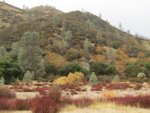
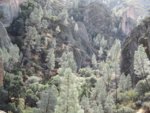
I like the Pinnacles during both seasons...less people than on the more "comfortable' shoulder seasons. I'd say West side during winter, east side during summer (there is a pool!). Summer means getting up at the crack ass of dawn and be done by 1 PM and winter means dress warmer and don't get up so early. Eating lunch by the reservoir is blah, do it on the Steep and Narrows part, just off to the side a little. Great view while feasting is the way to do it! I like the wilderness trail. that long one that follows the creek on the north side where you can easily get lost....maybe not so great in winter, but late spring and early summer is pretty super. Stay away during 3 day weekends or spring break. Careful of roving bands of raccoons, and do not leave anything unattended at the camp site if you aren't there....they'll steal it before you know it.Small National Park. Very few trails. Limited parking. One entrance on East, one entrance on West. Both dead end in the park and do not connect. Two awesome cave areas. Popular with rock climbers. Hot as hell during summer and fall. Rim trail has amazing views. Have lunch at the reservoir with the other 200 people you passed in the caves.
Edit1:
Sorry, these snaps are from Florence Lake, not Edison. Was looking at multiple folders and in my slightly out of whack state due to the orange sky, typed it out wrong.
Edit2: 6 day camp sites (best estimate) Should have stayed at #3 two nights in retrospect.