Did you meet him here?These MFers dont know what ballz deep means?
Open main menu button
REMINDER: THE ARENA PLATFORM, INC. has no obligation to monitor the Forums. However, THE ARENA PLATFORM, INC. reserves the right to review any materials submitted to or posted on the Forums, and remove, delete, redact or otherwise modify such materials, in its sole discretion and for any reason whatsoever, at any time and from time to time, without notice or further obligation to you. THE ARENA PLATFORM, INC. has no obligation to display or post any materials provided by you. THE ARENA PLATFORM, INC. reserves the right to disclose, at any time and from time to time, any information or materials that we deem necessary or appropriate to satisfy any applicable law, regulation, contract obligation, legal or dispute process or government request. Click on the following hyperlinks to further read the applicable Privacy Policy and Terms of Use.
So how big's it gonna get Wed/Thurs/Fri on west coast?
- Thread starter oneworlded
- Start date
Of course not. There are no hot blondes in San Diego. That's why they always say a San Diego 8 is a DelMarVa 3.Did you meet him here?
Some girl moved into my apt complex. She was from Oregon. Someone said she was an Oregon 9 but an LA 5.Of course not. There are no hot blondes in San Diego. That's why they always say a San Diego 8 is a DelMarVa 3.
She couldn't handle it so he moved back to Oregon.
She really did act like the belle of the ball.
We heard you, but does balls deep on 1" really count?These MFers dont know what ballz deep means?


Last edited:
Is the current victim a female? (self identifying counts)We heard you, but does balls deep on 1" really count?
That 2008 swell was "too" big for lots of SB spots at some times. El Cap had a left going straight into the right. Sandbar was unsurfable and they closed it off after some people got washed through the fence and into the harbor rocks, but Campus Point was perfect and biggest surf I've ever seen below Gaviota. There was no weather with that swell like there's gonna be with this one. This AM was ugly.
so whatever it ends up being, that’s what they end up calling itseems like it went from La nina to el nino in 2 weeks
There’s no correlation between Niño niña and rainfall totals in California. If you look at historical records it’s pretty clear.Yes.
In fact, if I'm not mistaken, the wettest years of the past decade have all been La Niña years.
But hey, we've got all this weather and climate stuff figured out.
Everywhere along the west coast will be 1ft Hawaiian
Because the swell isn't due until TOMORROW AFTERNOON.headed into work this AM - ocean was a farkn' mess.
Swell hasn't filled in, heavy duty south wind.")

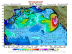
North CA: For advanced planning purposes expect swell arrival on Thurs AM (1/5) building to 18.2 ft @ 17-18 secs (30 ft) and very raw peaking right at a 5.9 ft high tide. Swell holding through the day. Swell Direction: 270 degrees
Last edited:
El Nino does correlate with higher snowfall totals in Southern California/Arizona, although it appears most of the Sierra is not necessarily strongly affected by it. Statewide rainfall may well be another matter entirely but I expect SoCal's water reservoir situation generally stands to benefit from an El Nino.There’s no correlation between Niño niña and rainfall totals in California. If you look at historical records it’s pretty clear.
The links for El Nino/La Nina are in the frame at left, under the zone listings.
Your Guide to Snowfall - Main Page
The most complete, comprehensive and objective guide to snowfall--and both prevailing and expected snow conditions--at North America's ski resorts ever published
bestsnow.net
There will be one spot on entire CC that will be clean and offshore.
Shorebreak will be 6'+ and the outside waves will be 20-25' monsters. Current will be wicked and the paddle out will be comparable to OBSF on a big clean day.
Anyone from Monterey area? PM me please. Have q.
Shorebreak will be 6'+ and the outside waves will be 20-25' monsters. Current will be wicked and the paddle out will be comparable to OBSF on a big clean day.
Anyone from Monterey area? PM me please. Have q.
@Ifallalot was ahead of the curve after all! I bet the water quality will beGet out while you still can!
with all the runoff.Even a 10kt south wind is enough to blow out 95% of the beaches.Maybe head to Long Beach for some manageable waves?
***
TODAY S winds 30 to 40 kt. Seas 10 to 17 ft.
TONIGHT S winds 30 to 40 kt, becoming SW 20 to 30 kt. Seas 14 to 23 ft. Rain with vsby 1 nm or less.
THU SW winds 15 to 25 kt, becoming W 15 to 20 kt. Seas 14 to 29 ft. Scattered showers and scattered tstms.
THU NIGHT W winds 10 to 20 kt, becoming W to SW 5 to 10 kt. Seas 20 to 26 ft.
FRI S winds 5 to 15 kt. Seas 12 to 19 ft.
FRI NIGHT S winds 5 to 15 kt, increasing to 15 to 25 kt. Seas 9 to 13 ft.
**
SAT S winds 20 to 30 kt. Seas 9 to 16 ft.
SAT NIGHT S winds 20 to 30 kt. Seas 10 to 17 ft.
SUN SW winds 10 to 20 kt, becoming S to SW 5 to 15 kt. Seas 11 to 17 ft.
SUN NIGHT S winds 5 to 10 kt, increasing to 10 to 15 kt. Seas 9 to 12 ft.


Last edited: